Maps
Maps are a wonderful resource, they help you visualize the surroundings of your ancestors and their journeys.
For the Netherlands there are two very interesting sites: Watwaswaar.nl (what was where) and HISGIS.nl (Historical Geografic Information System). Both are interactive sites with maps of the Netherlands. Neither has an English interface, but watwaswaar has an english introduction.
HISGIS contains the real estate map of 1832, which describes every parcel of land. Owner, location and use are listed in the description, the boundaries are drawn on the map. You can search by owner, or by land use, or both. You can see just the parcels, or the parcels with the building on it. You can search a small Google map to get you to the right place. HISGIS does not cover all provinces yet.
Watwaswaar works somewhat different. As there are maps from different times, you can get different parts highlighted. The information about the highlighted area is displayed at the right. When you choose ‘Alle soorten informatie’ (all information) all parcels of land in 1832 are drawn in and you can click on a parcel on the map and see the information about the owners at the right. While Watwaswaar covers all provinces, it does not cover everything in the same detail.
The 1832 map was made to collect taxes, so only owners are listed.
I have had the best results with maps of Almelo. Most of my ancestors lived in 1832 in Stad Almelo.
So here is a short list
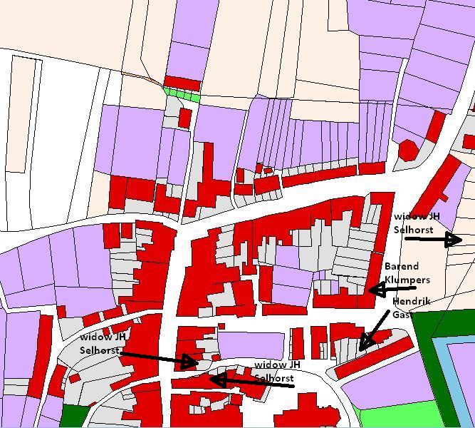
2nd great-grandpa Hendrik Gast owned a modest piece of real estate (a house and yard) in the Bunsing in Stad Almelo. He was a merchant and store keeper.
The widow of 4th great-grandpa Jan Hendrik Selhorst (she was his second wife, and not my 4th great-grandma) owned three houses in the Bunsing in Stad Almelo, and a piece of farmland in the Oost Eschhoek lands.
3rd great-grandpa Barend Klumpers surprised me. Not only did he own several pieces at the Doelen (#530-531), a modest parcel, which seemed appropriate for a tailor. He also owned a
parcel of farmland in the Boomshoek (Ambt Almelo, Section H, Agterland #134),
a number of parcels (also farmland) in the Schelfhorst (Ambt Almelo, Section B, Oost Eschhoeklanden #1301, #1015, #1292, #1189, #1118, and #1117), but also another house and yard in town (Section A, Schokland parcel#186, house#159), a small garden at the Doelen (Section A, #524a), and a house and yard at the Bartelshoek (Section A, parcel#248, house#219).
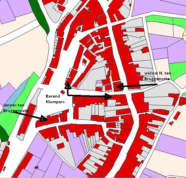
3rd great-grandma Maria Christina Nieuwert, widow of Hendricus ten Bruggencate owned three small pieces with a house on each in the Schokland. She was a baker (she took over the bakery after her husband died). She is not taxed on a store.
3rd great-grandpa Jannes ten Bruggencate owned two small parcels (#267 and 268) in the Bartelshoek. He was a skipper. A Jannes tB also owns a piece of farmland in Ambt Almelo, but his occupation was bleacher. Now it was perfectly possible that he did both, he transported things in his boat, and he or someone in his family also did some bleaching. And as there really is no other Jannes at that time, I think it is the same one.
Quite a few other relatives own houses and pieces of land in Almelo.
It’s fun to figure all this out. And it would be interesting to know, who was living in the houses, that were owned by family. But that would require other sources to find addresses, and then compare those with these maps.
Leave a Reply